|
              
MINI ANIALARRA EXPEDITION (October 2000)
Heaven and Hell!
  
In the second week of October, three "fanatics" (Rudi, Paul & Annette)
went to the Anialarra again. We had a long list of things to do:
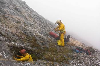
- Determine the correct UTM-coordinates and altitude of some caves
(AN534, A4, AN542, etc..) because I had found some anomalies when pinpointing
them onto the big overview survey.
- Checking and exploring several caves, partly discovered by us these
past years, partly by our predecessors (E.S.S. in 1985-86 and SSP in
1991-93)
- Fine-tuning a new method of systematical prospection and exploration
of the zone. The problem is that the Anialarra-zone has been searched
over and over again, but never in a systematical way. So nobody knows
what has been done and what not.
There was a certain risk involved in our expedition: normally October
is a sunny and dry month, but early snowfall does happen. In the case of
snowfall, it is absolutely impossible to work in the zone...
Sunday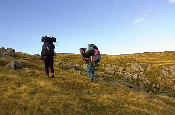
All camping equipment was carried up, and a small camp was set up at the
usual spot at 2100m of altitude. The rest of the day was spent, looking
after about 10 different entrances of caves that we would re-explore in
the coming week. The weather was beautiful!
Monday
Again, sunny weather. The rest of the equipment (caving equipment)
was carried up. It was a lightweight expedition; we had only 200 m. of 9
mm rope. That day we tried out our new "systematical exploration" method
and it went fine. It goes like this: the complete zo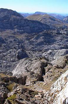 ne
has been divided in 100 by 100 metres squares. Every square has a unique
code (e.g. A17). The corners of each square correspond with an integer UTM-coordinate.
E.g. square F23 is between X-coordinate 683,700 and 683,800; and Y-coordinate
4757,500 and 4757,600. Now, using a precise GPS, these 4 points are located
onto the terrain, and marked with a flag so that they are visible from far.
Then, we check this square in a very detailed way: every crack, pit, fissure,
sinkhole and so on is verified. Every pit is abseiled, even those who have
already some kind of mark or show signs that they have been explored before.
Everything is written down or sketched; the coordinates of each cave-entrance
are taken by GPS, and if the cave is somewhat important (let?s say deeper
than 15 m), it is given a number that is marked with red paint (discretely)
at a visible spot. ne
has been divided in 100 by 100 metres squares. Every square has a unique
code (e.g. A17). The corners of each square correspond with an integer UTM-coordinate.
E.g. square F23 is between X-coordinate 683,700 and 683,800; and Y-coordinate
4757,500 and 4757,600. Now, using a precise GPS, these 4 points are located
onto the terrain, and marked with a flag so that they are visible from far.
Then, we check this square in a very detailed way: every crack, pit, fissure,
sinkhole and so on is verified. Every pit is abseiled, even those who have
already some kind of mark or show signs that they have been explored before.
Everything is written down or sketched; the coordinates of each cave-entrance
are taken by GPS, and if the cave is somewhat important (let?s say deeper
than 15 m), it is given a number that is marked with red paint (discretely)
at a visible spot.
This way, one can finish a square, and know for sure that never again
we, nor somebody else, has to do this again. One small problem: the upstream
zone (were we work right now) counts about 200 squares; the downstream zone
even more! One square is often one day of work....! It is clear that we
still have work for many years to come. Anyone interested in joining us,
is welcome!
Tuesday
 The
weather had changed dramatically. It was raining and we decided to stay
as much underground as possible. We re-explored the AN60, where Rudi succeeded
in passing the old terminus (-95m) by forcing himself through a squeeze.
But a bit further on, it became too narrow, without much airflow. But, at
-40m we managed to locate the strong draught again that can be felt in the
first part of the cave. The draught disappears in a small gallery, that
could be made accessible after some digging work. To be continued. The
weather had changed dramatically. It was raining and we decided to stay
as much underground as possible. We re-explored the AN60, where Rudi succeeded
in passing the old terminus (-95m) by forcing himself through a squeeze.
But a bit further on, it became too narrow, without much airflow. But, at
-40m we managed to locate the strong draught again that can be felt in the
first part of the cave. The draught disappears in a small gallery, that
could be made accessible after some digging work. To be continued.
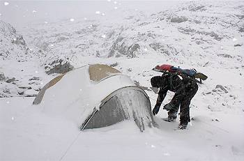
That night, a storm kept us awake all night. The storm lasted for 8 hours
and wind speeds of 140 km/h were registered in the nearby weather station
of Soum Couy. Our Northface tent survived barely, and so did we...
Wednesday
 Rudi
and me went to the AN211, a -350m cave that still had an un-explored pitch
at -50m. But the cave was in flood conditions, and so was that new pitch.
We had to give up our attempt and when we got out of the cave, the lapiaz
had changed colour: a blanket of snow covered it all! The snow fell rapidly,
we headed (heavily loaded) back to the camp. We decided to go down to the
valley again, with a part of the gear. Going down was really difficult,
about 15 cm of snow had covered the track and finding the way was often
guess-work. The combination of snow, limestone rock and heavy backpacks
wasn?t too good neither, we slipped and fell several times. Rudi
and me went to the AN211, a -350m cave that still had an un-explored pitch
at -50m. But the cave was in flood conditions, and so was that new pitch.
We had to give up our attempt and when we got out of the cave, the lapiaz
had changed colour: a blanket of snow covered it all! The snow fell rapidly,
we headed (heavily loaded) back to the camp. We decided to go down to the
valley again, with a part of the gear. Going down was really difficult,
about 15 cm of snow had covered the track and finding the way was often
guess-work. The combination of snow, limestone rock and heavy backpacks
wasn?t too good neither, we slipped and fell several times.
The weather forecast was really bad: snow for the next three days! This
made us decide to go up the mountain again the next day, and to get the
whole camp down (if possible). Leaving the camp there until Saturday, the
very last day of our stay, was too risky. A very wise decision, we would
later find out!
Thursday
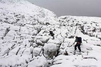 We
went up again, and found the camp in a picturesque landscape of snow and
rock. Blizzard conditions whilst packing our backpacks... 4 hours later
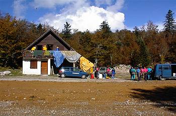
we were back at the ARSIP-bungalow, and much to our surprise the sun was
shining and life suddenly looked good again. Another surprise was the presence
of 16 french "gendarmes", who had planned to make a Gouffre Pascale - Salle
Verna through-trip that evening. We
went up again, and found the camp in a picturesque landscape of snow and
rock. Blizzard conditions whilst packing our backpacks... 4 hours later
we were back at the ARSIP-bungalow, and much to our surprise the sun was
shining and life suddenly looked good again. Another surprise was the presence
of 16 french "gendarmes", who had planned to make a Gouffre Pascale - Salle
Verna through-trip that evening.
Friday
To save our week, we went to do some "classic caving". The Arresteliako
Ziloa (Trou Souffleur de Larrandaburu) is situated near Ste-Engrace, not
far from the tourist attraction "Gorges de Kakouetta". After many years
of work, the big continuation was discovered in the beginning of the Nineties.
After hardly 10 years of exploration, the cave has passed the 50.000 m in
length, and can be considered as being the biggest discovery at the Pierre-St-Martin
Massif of the last 30 years. The cave not only is big and complex, but beautifully
decorated and nicely sculped as well. We went as far as the streamway, at
a depth of -300m. An unforgettable trip, and really a pity that we didn?t
take our photo camera with us.
 That
evening, the snow-limit had descended and it even snowed heavily at the
altitude of our bungalow (1600m). We were very glad to have dismantled the
camp, and even more happy when we later heard that the snow had reached
60 cm in height, up in the mountains! That
evening, the snow-limit had descended and it even snowed heavily at the
altitude of our bungalow (1600m). We were very glad to have dismantled the
camp, and even more happy when we later heard that the snow had reached
60 cm in height, up in the mountains!
Conclusion
We had a lot of fun, but because of the bad weather the results of our
explorations were a bit disappointing. Next time, we will come a bit
earlier, probably by the end of September.
All pictures by Rudi Bollaert
|